
We are going to look at how we update/apply a filter for a layer in a WebMap in ArcGIS Online using the …

Today’s blog post is inspired by a question posed on Esri Communities. The question asks how to export hosted feature layers using …

On many occasion I have been handed a file containing geographic coordinates (csv, txt, etc.) to convert to point geometry and view …
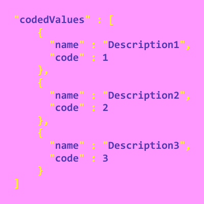
The ArcGIS API for Python has a query_domains() method for a Feature Layer Collection object. A Feature Layer Collection object represents a …

If you have ever had to reset the extent of a WebMap after it has been let out in the wild for …

Why create this workflow… Every week I put time towards answering questions on three main platforms; GIS StackExchange, Esri Communities, and Reddit. …

A decade ago I purchased the first edition of Learning Geospatial Analysis with Python by Joel Lawhead. I was fresh from graduating …

Discuss the Differences Between Geographical Information Systems & Geographical Information Science.
I was digging through some material from my MSc in Geocomputation from Maynooth University and came across this exam question. The MSc …

If you are interested in learning ArcPy, check out this course. This tool will allow you to create a new linear feature …

In this blog post we will assess using ArcPy to zoom to a layer or a selection for If you are interested …

This is a revamp of an old blog post from over 8 years ago that received great feedback at the time so …

Data can often be provided as a Shapefile with an accompanying file containing the attribute information, or surplus attributes to compliment those in the Shapefile, …

In this blog post we will assess the options for extracting layers and tables from an ArcGIS Online Feature Service to Feature …
Unleash the full potential of Definition Queries as you dive deep into their intricacies! Gain a profound understanding of Definition Queries and …
Discover the power of automating your ArcGIS Online Content Management with our groundbreaking course! Are you ready to revolutionize your ArcGIS Online …

ArcGIS Pro 3.2 added three new parameters to the Search Cursor (and Update Cursor) with ArcPy. These parameters are named spatial_filter, spatial_relationship, …
Unlock the Power of ArcPy: Elevate Your GIS Skills with Data Management and Geoprocessing in ArcGIS Pro! Are you ready to take …
Spatial Thoughts on LinkedIn posted the following challenge…Can you take a dataset of a river centerline and varying lengths of line transects …
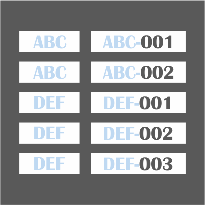
Many years ago I came across the How to Create Sequential Numbers in a Field in ArcMap using Python in the Field …
You have made a selection based on attributes or location in ArcGIS Pro (or via a script or tool) and you want …

The Cartographic Information Model (CIM) is a map content specification for cartographic descriptions of GIS datasets and Project components in ArcGIS Pro. …
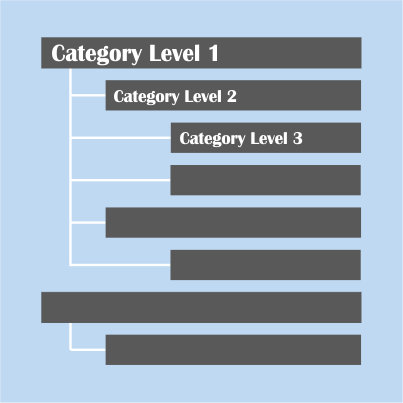
Creating an Item Categories Schema with the ArcGIS API for Python (API) can be somewhat difficult to get your head around, hopefully …

The Polygon to Line (Data Management) tool is only available in ArcGIS Pro with an Advanced license. You can check out the …

I was recreating the ArcPy Feature Vertices to Points tool using GeoPandas and Shapely and I was unimpressed with the length of …

If you head over to the ArcPy page you will find a couple of custom toolboxes that we have been creating. These …

You may come across a couple of scenarios…1. You have published a hosted feature service to ArcGIS Online (AGOL) with domains and …
The Sort (Data Management) tool has limited functionality on a Basic and Standard licence, you can only sort by one field and …

The Create Random Points (Data Management) tool is available with an Advanced license or on a Basic or Standard license if you …
I remember being thrown into the deep end when it came to using ArcPy. The manual tasks were racking up, the human …

This became a pet project of mine back in 2017 where I first implemented using open source geospatial Python modules, osgeo and …

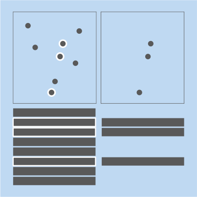
A common task is to calculate the percentage overlap between a polygon feature class overlaying another polygon feature class. One general workflow …

Not the most fanciest of tools but another one none-the-less that you can by-pass the Advanced license requirement and create your own …
The Table to Excel tool from the Conversion toolbox is a stalwart amongst Geoprocessing tools but it does have its limitations, namely; …

The most common approach to creating a Feature Class or Table sorted by a particular field(s) is using the Sort tool in …

This one re-uses plenty of lines of code from the Split Line at Vertices tool. The Split Line at Point (Data Management) …

This was a fun one to do! The Feature Vertices to Points (Data Management) geoprocessing tool is only available in ArcGIS Pro …

The Split Line at Vertices (Data Management) geoprocessing tool is only available in ArcGIS Pro with an Advanced license. Here’s how you …